TruFlite for Windows Workshop - www.truflite.com
[Home] | [Workshop] | [30" Data, Overview] | [Data Import, 30" Data] | [Scene 1] | [Scene 2] | [Scene 3] | [Scene 4] | [Colorize] | [Scene 5] | [Scene 6]
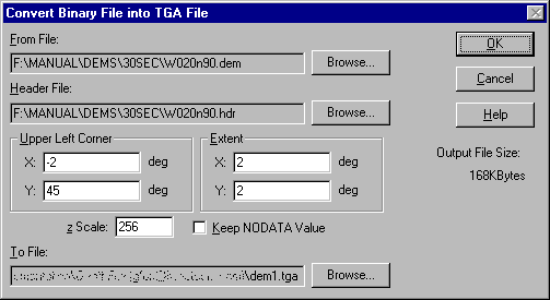
Let's use a Europe file of the GTOPO 30 arc second data set: "W020N90".
Cut a 2° by 2° sample, northwest corner at 2°W, 45°N.
| Dialog "Calculate/Import Filters/Binary DEMs..." | Result: "dem1.tga" |
|---|---|
|
|
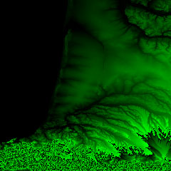
"dem1.tga" is the file TruFlite needs to create 3D perspectives of the terrain.
Each pixel represents an integer number containing the elevation value. In the above import dialog we specified z Scale: 256. The data source file "W020N90.DEM" contains elevation values in meters. Each value is then multiplied by 256 and stored as a colored pixel in "dem1.tga".
Here are some samples for how TruFlite's TGA files store the elevation values:
| Elevation | Red | Green | Blue | Color |
|---|---|---|---|---|
| 0 | 0 | 0 | 0 | |
| 1 | 0 | 0 | 1 | |
| 255 | 0 | 0 | 255 | |
| 256 | 0 | 1 | 0 | |
| 512 | 0 | 2 | 0 | |
| 24000 | 0 | 93 | 192 | |
| 1000000 | 15 | 66 | 64 | |
| -1 | 255 | 255 | 255 | |
| -24000 | 255 | 162 | 64 |
Our file "dem1.tga" always has Blue = zero because all elevation values are multiples of 256.
Let's use this file as the only input file for "scene1.trf", our first step.
This page was last updated:
11/10/23.
Copyright © 1996-2023 Martin D. Adamiker's. All Rights Reserved.