TruFlite for Windows Workshop - www.truflite.com
[Home] | [Workshop] | [30" Data, Overview] | [Data Import, 30" Data] | [Scene 1] | [Scene 2] | [Scene 3] | [Scene 4] | [Colorize] | [Scene 5] | [Scene 6]
From now on, all changes are only applied on the view parameters. We will always use the same imported "dem1.tga".
When we choose, "File/New", and specify our imported "dem1.tga" as the elevation file, we are ready to render an image: "Calculate/Final...".
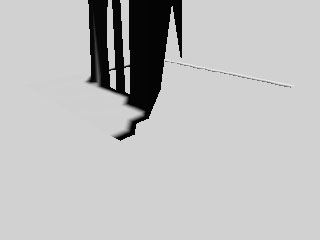
| Image "sc1_000.tga" |
|---|
|
|
The corresponding TruFlite scenery file is "scene1.trf" (you might have to correct the relative path: "../dem/dem1.tga").
What's wrong with this image?
The z scale factor is set far too high (default of 0.1). Mountaneous parts of the image have not been rendered at all. The polygon sides resemble skyscraper walls. This comes partly from our default "z Scale" factor of 256 during the import process (each elevation point was multiplied by 256 at the import).
Save the result as "scene2.trf" - our next step.
This page was last updated:
11/10/23.
Copyright © 1996-2023 Martin D. Adamiker's. All Rights Reserved.