Help
What Is TruFlite?
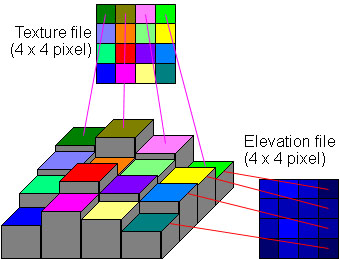
Martin D. Adamiker's TruFlite for Windows is a 3D landscape rendering system. It is able to create photorealistic images. The input data needed are a DEM (Digitel elevation model) file and a texture file.
Here is a (very small) example of how texture and elevation data are combined. Each colored square represents a pixel. TruFlite does not render each pixel as a flat area, it rather interpolates both the elevation and the texture data (it creates a seamless mosaic of bezier surfaces).
What's the Price?
TruFlite for Windows is US$ 295 for a single commercial license, and US$ 195 for an educational license.
Upgrades to future versions of TruFlite for Windows will be available for a free download. Once you have a license, it will remain valid without additional fees.
Why Choose TruFlite?
Just have a glimpse at our fact sheet.
How Can I Create an Image?
Have a look at our Workshop page.
The process of importing data (DEMs and textures) is now greatly simplified by TFMAKE.
TFMAKE is a 32bit console program that automates the entire process of downloading, converting, importing and rectifying of elevation and texture data from the Internet for a specific 1 degree DEM quad anywhere in the U.S.!
For visualizing the area around San Luis Obispo, CA, all you'll have to do is enter:
TFMAKE_3ARCSECOND.BAT -120 35
and TFMAKE will get the DEM from the USGS, the texture data from the Census Bureau, convert them into the TGA format, rectify the texture file so that it is geographically correct (relative to latitude) and write a TruFlite parameter file so that the user can simply start TruFlite, open the parameter file and click on the Render button.
DEM (Digital Elevation Model) Specifications
A DEM is an array of elevation data. Here we refer to regular grids only. A landscape can be described as a table of z (elevation) points having (x, y, z) coordinates each. The layout of the data can vary. The 1 degree U.S. Geological Survey DEMs for example are ASCII files.
TruFlite uses a binary representation: TGA files, which can also be read by other bitmap editors.
DEM Sources, data characteristics. Bold numbers represent exact values, other numbers are approximate values.
| Name | Height of a pixel | Width of a pixel | Vert. reso- lution |
Average file size | Coverage | |||
|---|---|---|---|---|---|---|---|---|
| meters | arc sec. | meters | arc sec. | meters | zipped | un- zipped |
||
| USGS 1 degree DEMs | 90 m | 3" | depends on latitude, 64 m on 45° N | 3" | 1 m | 2 MB | 9.5 MB | U.S. + Puerto Rico (100%) |
| USGS 30 meter DEMs | 30 m | 1" | 30 m | depends on lat., 1".41 on 45° N | 1 m | 180 kB | 1.1 MB | U.S. + Puerto Rico (approx. 50%) |
| USGS 30 arc second DEMs | 900 m | 30" | depends on lat., 636 m on 45° N | 30" | 1 m | 12 MB | 60 MB | Global coverage |
Texture File Specifications
To draw streets, power lines, railroads, drainage, etc. on the landscape you will need some texture information. TruFlite uses texture mapping. That means you have to provide a bitmap file that fits over the landscape. The Tiger Mapping Service yields such bitmaps interactively. Of course you can use any bitmap you want including aerial and satellite pictures.