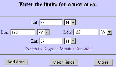
38°N
37°N
TruFlite for Windows Workshop - www.truflite.com
[Home] | [Workshop] | [SRTM, Overview] | [Data Import, SRTM] | [Scene 1] | [Scene 2] | [Scene 3] | [Scene 4] | [Colorize] | [Scene 5] | [Scene 6]
Under agreement with NASA, the USGS EROS Data Center distributes and archives SRTM data in accordance with a joint partnership Memorandum of Understanding between NASA and NIMA (July, 2002).
SRTM data can be obtained via the USGS Seamless Data Server Distribution System - Enhanced.
Let us retrieve the one by one degree area around San Francisco:
|
38°N |
||
| 123°W | |
122°W |
|
37°N |
Let us start at their home page:
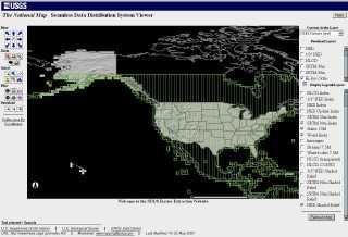
View and Order Data Sets - United States Viewer: http://seamless.usgs.gov/start.htm
| Start page of the SDDS Raster Extraction Website |
|---|
 |
To the right, select "Download Layers/Raster/SRTM 30m".
At the left margin, follow the "Define Area By Coordinates" link. Switch to decimal degrees and enter the desired coordinates:
| Hard copy: Limits |
|---|
 |
Click "Add Area".
| You'll be asked this: |
|---|
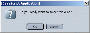 |
Clicking "OK" yields this result:
| Data Extraction Request Pieces: | ||||
| Product | Southwest (Bottom Left) Corner | Northeast (Top Right) Corner | Size (MB) | Link |
| SRTM - ArcGrid format | ||||
| 37.000000 N, 123.000000 W | 38.000000 N, 122.000000 W | 54 | Download | |
Before clicking "Download", you have to modify the request: We need BIL the format.
| SDDS-Enhanced Request Options Page: | |
| Requested Product(s): | select only "SRTM 30m - Shuttle Radar Topography Mission" Data Format: change the selection to "BIL". Archive Format: ZIP Metadata Format: HTML |
| Breakup of request into pieces: | Maximum size per piece: 100 MB |
| Display Options: | WGS84 Coordinate Display: Decimal Degrees |
| Media Options: | Order this request on Media? No |
Click "Save Changes & Return to Summary"
| Data Extraction Request Pieces: | ||||
| Product | Southwest (Bottom Left) Corner | Northeast (Top Right) Corner | Size (MB) | Link |
| SRTM - BIL format | ||||
| 37.000000 N, 123.000000 W | 38.000000 N, 122.000000 W | 26 | Download | |
Click "Download". A new browser window opens:
Current order status
Adding your request to the queue.../Extracting data.../Creating the archive
file...
Please wait for the data to be returned.
The dialog to save the resulting ZIP file should open automatically. Choose an appropriate location and name for the ZIP file, e. g. 85311761.ZIP.
Contents of the ZIP file:
Archive: 85311761.ZIP
Length Date Time Name
-------- ---- ---- ----
25927200 06-24-03 10:47 85311761/85311761.BIL
     222 06-24-03 10:47 85311761/85311761.BLW
     180 06-24-03 10:47 85311761/85311761.HDR
    4099 06-24-03 10:47 85311761/85311761.PRJ
      22 06-24-03 10:47 85311761/85311761.STX
   20537 06-24-03 10:47 85311761/METADA~1.HTM
-------- -------
25952260 6 files
We need to extract the BIL and the HDR file.
Now, let us run TruFlite.exe:
Calculate/Import Filters/Binary DEMs...
From File: *.BIL
Header File: *.HDR
At this point TruFlite complains:
| Problem when using the standard HDR file: |
|---|
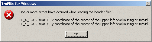 |
Though the error message is not quite correct, it indicates that the HDR file does not contain all required information.
This error message may not appear in future versions of TruFlite for Windows - we are currently evaluating pros and cons.
For the time being, edit the HDR file as follows:
| before manual editing | after manual editing |
|---|---|
BYTEORDER I LAYOUT BIL NROWS 3600 NCOLS 3601 NBANDS 1 NBITS 16 BANDROWBYTES 7202 TOTALROWBYTES 7202 BANDGAPBYTES 0 |
BYTEORDER I LAYOUT BIL NROWS 3600 NCOLS 3601 NBANDS 1 NBITS 16 BANDROWBYTES 7202 TOTALROWBYTES 7202 BANDGAPBYTES 0 ULXMAP -123 ULYMAP 38 XDIM 0.00027777777778 YDIM 0.00027777777778 |
The ULXMAP value is the westernmost longitude of the data, the ULYMAP value is the northernmost latitude. The XDIM/YDIM values are the extent. All values are measured in degrees.
| TruFlite data import dialog, all data entered | Result |
|---|---|
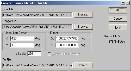 In the above dialog, we leave the default value of 256 for the z scale. Thus, the unit of the output file is 1/256th of the original. Why are we doing this? Because the elevations can be interpolated much better if the units are small. The TruFlite TGA file bandwidth allows for 16 million distinct elevation values. The factor 256 does not cause any rounding errors, so the full information is transferred into the TGA file. |
 |
 This indicates -120 to 996 elevation units. The PRJ file contains the unit description: units METERS It is a good idea to use 1,000 as the z Scale: The new unit would then be millimeters. |
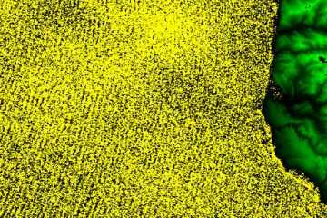
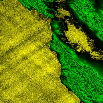
In this original size section of the above picture, see how
beautifully the waves are coming in!
|
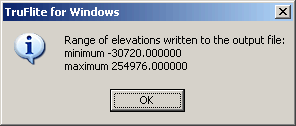
To get an idea of the wave height during the data acquisition, we searched for minima and maxima in the TGA file:
R/G/B: 255/248/1 (occurs very scarcely) is -8 meters;
R/G/B: 0/2/0 is +2 meters; +4 meters occur, but only once or twice, so maybe they hit a boat.
Basically, the average elevation seems to be less than zero meters in the raw data... We may work out a histogram of the interesting regions some day.
This page was last updated:
11/10/23.
Copyright © 1996-2023 Martin D. Adamiker's. All Rights Reserved.